Cooke City to Red Lodge
Day 11
During the night it rains heavily. I think for sure that the Beartooth Pass will be closed due to snow. I dream of snow and a bagged ride -- all of us van-shuttled to Red Lodge. [This turned out to be more prophetic than I ever would have realized!] That would be incredibly disappointing, inasmuch as, in some ways, today's ride is what we've spent the past 10 days training for -- 11,000 feet! Is it a challenge? Or a monkey on my back, this culmination day? The pass is clear, the skies cloudy, and streets in Cooke City are dry. The ride's a "go!" Park Two accomplished, Peak Two coming up.
Most of the in-town group is gathered in clumps at three large tables at homey family restaurant, finishing an early breakfast feast. I order the sourdough pancakes - how could a San Franciscan resist? They are tasty, albeit sourer than most.
It's cold. Previously familiar faces are obscured by balaclavas and hoods. Cold weather gear has come out of hiding. Howard is recognizable only because of his size and his Otis Guy bike. Others are recognizable only by their bikes.
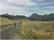 Heading up Colter Pass (elev. 8,000'), my long-forgotten mid-western instincts tell me that this feels like impending snow! It's 8:15 a.m. My feet are cold, but my body is warm. And my usual situation...a significant hill within 5 minutes on the road.
This roads takes us over the pass only to run us on a wonderful downhill, seemingly to sea level, before taking us to the 10,947' Beartooth summit. I'm lusting after "easy" rather than "challenging" hills.
It's 11:15 a.m. and we have 16 miles to the summit. Again, as in the first day, I am pedaling somewhat against a clock. We've gone 20 miles in 3 hours. Not a terrific rate of speed, but it's been steadily uphill most of the way. I'm averaging 4-6 mph, pedaling along like a well-oiled machine. This hill is relentless in its climb, but isn't steep. Maybe a 5% grade. We pass Beartooth Lake on our left. This reminds me of the Alaskan fields of Denali Park, although not in the full red dress of Alaskan autumnal tundra.
Seven or eight switch backs lead to the summit. It's cool, but I remove my rain outfit and pedal in capilene(tm) and thermax(tm) shirts, keeping shoe covers on for warmth. I have all possible rain/cold weather gear available for our downhill run. We enter the snow line at a low altitude -- purple-wild-flowers-and-evergreen-tree altitude. Climbing above the tree line, we pedal in and out of light snow flurries. What a change from the 90 deg. of two days ago! Behind us a charcoal storm cloud races our direction.
The low scrub of the tundra stretches as far as we can see. The views, although impacted by the weather, are gorgeous. We are surrounded by gray stone peaks, snow fields, tundra, with dramatic light and shadow patterns moving across the mountains. In the distance a cloud settles to the earth, filling the valley below. Rain. Or snow. Charles Kuralt writes that this is one of the most picturesque highways in America. He surely is correct.
We pedal to "The Top of The World," a provision store on the west side of the summit. Colby, a young Samoyed, is fascinated by Rufus and spots him as I park my bike. Racing from the porch, small white ears at attention and black beady eyes focused on Rufus, he is hell bent on sniffing and nuzzling Rufus in a mating ritual. Colby persists -- preferring to woo Rufus over a proffered piece of peanut butter sandwich.
The store owner advises that the road gradient flattens out on the remaining switch backs to the top. I've been "training" for this summit for the last 10 days and we're doing it. And it isn't hard! Even at this altitude! I'm psyched. Still not in my granny gear either; doesn't look like I'll need it. I CAN DO THIS! Up ahead is the blue van. We must be at the west summit! 10,947 feet! HOT DAMN! Greg snaps pictures of each rider as we reach the summit. I have made it!
The surrounding peaks are shrouded in menacing cumulus clouds. Distinguishing low-lying clouds from mountain-side snow fields is a challenge. Off in the distance is Beartooth Peak. About 2,000' below, a cloud layer completely obscures the Red Lodge valley and base of the mountains. The views, even in this weather, are incredible. Posed in front of the brown Department of the Interior "summit" sign, we take the requisite number of "I made it!" pictures and retreat to the shelter of the van to don the rest of our warm clothing. We have a slight descent and then another short ascent to the east summit (lower) before our downhill run to Red Lodge, 26 miles away. That ominous black cloud is still chasing us.
We descend rapidly in another downhill dash. The roads are dry and there are few cars. There is no evidence of black ice, a hot topic of conversation last night in the bar with the Branch Floridians (otherwise known as Team Floride -- two judges from Florida).
At this second summit a group of tourists, most with fancy black cameras dangling from necks warmed by trendy cold weather gear, are enjoying the view and are interested in what we are doing. And in particular, "WHY on earth...?" or "Who would want to...?"
From this vantage point, it's clear that clouds completely fill the valley. I am warned by a tourist who has just come up from Red Lodge that I will soon be in fog on our descent. I grin and take off. I'm into the 26 mile descent. Terrific!! Wow. Flying down these switch backs -- 30 mph, occasionally 35.
Bam! Fog and snow. Snow! Snow? Snow?? We weren't warned about snow. Where did this come from?
I'm grateful for my new polar fleece balaclava. It's rapidly gathering an ice coating around the peek hole. The fog thickens to pea soup. With careful squinting, I'm able to see 50' ahead. My sun glasses are iced up. They provide eye protection against the considerable loose gravel on this road and I'm reluctant to remove them; I'm not anxious to get a face full of sand and stones. On the other hand, I can see better without them. I feel incredibly vulnerable. My Vista(tm) tail light bracket broke two days ago. I only have my reflective yellow triangle to warn overtaking traffic of my presence. My thumbs are numb. 15 mph is too fast for these conditions. At this rate, I'll be on this road for over an hour. My thumbs are colder than numb, if that is possible. These lobster mitts aren't protective, even with the glove liners.
Where is everyone? These conditions are terrible. Occasional yellow directional arrows point around dangerous curves. The road edge barriers don't look protective. Intuitively I know that were I to slide off the road, it's a long way down.
There's Chuck off the side of the road. His red rain suit is a most welcome beacon. He's off his bike, standing with his arms akimbo, hands tucked into his arm pits. I wonder why he is stopped? His thumbs are numb, perhaps even more so than mine. I, too, snuggle my hands next to my body. He mentions my shivering and suggests that if we see the van, we should sag down. Yup. I successfully climbed the peak. I don't have to prove that I can coast downhill.
Three of us begin our descent again, very slowly. We've gone 14 miles on this poorly maintained road, in near whiteout conditions -- 12 to go. It's 4 p.m. In the thick mist, the blue van appears at the side of the road. If I were warmer and more limber, I would jump for joy! We coast over to it. Dave is driving and says, "The yellow truck is 1/2 mile away, around the next bend or two. Can you make it?"
"Yes!"
Off we go to load our bikes on the Bike Centennial truck. Dave will pick us up there. Inside the baggage area of the warm truck we wait for Dave. Barbara is already in the truck, and relates the experiences of some of the other riders. Fortunately Steve (Bike Centennial) was prepared for this possibility, doing an excellent job in maintaining safety for us all.
We ride in the van the last 12 miles to town eventually running out of the fog and snow into light drizzle and wet roads, passing cyclists who chose to pedal the whole way.
With this weather, tonight's camping has been canceled and the two near-in motels, LuPine and Yodeler, make generous accommodations in their schedules to handle as many of us as possible. There is a hot tub, but I opt for a long, very hot shower. This offends my California drought mentality, but I think it is nearly a medical necessity. It's luxurious!
Wondrously, Wacky and Kyle of Wacky's Bike Shop are at our motel to take care of bikes. Kyle remembers that I was the first to call back in August to make shipping arrangements for my bike, and she takes it in tow, removing it from the motel laundry room to their bike shop.
Our final group dinner is put on by a group raising money for a Montana native animal facility. Originally planned for the town park, the noon weather dictated it be rearranged to an indoor facility. This small town's ability to be extraordinarily flexible in its planning is impressive.
After dinner, an excellent way to end a trip, many say good-bye. We revel in our accomplishment and are reticent to disperse. This has been a memorable trip. We don't, nearly as a group, want it to end. So instead about 15 of us drift from dinner back to the Snow Creek Bar.
Go to:
Table of Contents
Gardiner through Yellowstone NP to Cooke City (Day 10)
Leaving Red Lodge (Day 12)
Judy Colwell's Home Page
jcolwell@stanford.edu
Copyright Judy Colwell, 1996. All rights reserved.
Last modified: August 12, 2004